Robert John Bryant (1943-2022)
National Mapping Technical Officer and Computer Systems Officer 1969-1987
By Laurie McLean October 2022

Bob Bryant at Orroral in 1975.
XNatmap image from Klaus Leppert (1925-1995).
Bob Bryant came to National Mapping’s Canberra office in 1969 as a Technical Officer (Surveying) Grade 1 and went on to become a Computer Systems Officer Grade 3 prior to leaving Nat Map to join Dr Ben Greene’s Electro Optic Systems Pty Limited in 1987.
This article is a tribute to Bob Bryant who made significant contributions to Australia’s national mapping effort during some 18 years of dedicated service in several technical field with the Division of National Mapping. Here, Bob was affectionately known as Big Red, owing to his physical size and hair colouring. He is fondly remembered as a really dependable, efficient and likeable operator, as well as a good mentor and teacher, a straight shooter, and just a good bloke.
While this article is primarily focussed on Bob’s National Mapping career, he was more importantly, a beloved husband, and much loved father and grandfather.
Early life
Bob Bryant was born in Goulburn on 7 March 1943, the first of the 3 children born to Arthur James Bryant (1915-1999) and his wife Jean Thelma Bryant neé Orford (1929-1989).
Bob commenced his formal school education at the Goulburn Public School (Bourke Street) located at 204 Bourke Street Goulburn. After completing primary school at Bourke Street, Bob Bryant attended the Goulburn High School in Goldsmith Street. Here, Bob completed his formal high school education with the Leaving Certificate examinations at Goulburn High at the end of the 1960 school year. In these exams, Bob achieved passes in 6 subjects, namely: English B, Geography B, Mathematics I B, Mathematics II B, Physics A, and Chemistry B.

A recent picture of the main building at Goulburn High School.
Image from Goulburn High School web site.
During 1960, Bob met Robyn Frankel at Goulburn High School where Robyn also completed the Leaving Certificate that year. Robyn and Bob became engaged to be married during 1966. Their courtship endured many months of separation as Bob undertook survey work in remote areas including the Northern Territory and the then Australian Territory of Papua New Guinea. Bob Bryant and Robyn Frankel married in the now heritage listed St Saviour’s Cathedral in Bourke Street Goulburn on 18 March 1967. (St Saviour's Cathedral is the mother church of the Anglican Diocese of Canberra and Goulburn.)

St Saviour’s Cathedral Goulburn.
Edited image from Organ Historical Trust of Australia web site.
Department of Main Roads 1960s
After he completed high school, Bob Bryant joined the then New South Wales Department of Main Roads. Initially, Bob was employed as a trainee draftsman and later became a survey technical officer. While with Main Roads, Bob was based at Goulburn and later in Sydney.
LW Wordsworth and Associates, Young NSW
Between about 1965 and 1969, Bob Bryant worked for the private-sector surveying practice of LW Wordsworth and Associates that was based in the town of Young on the New South Wales South West Slopes about 370 kilometres south‑west of Sydney. However, the practice also had offices in Darwin and in Papua New Guinea. Thus Bob Bryant was to spend some time surveying out in the field while nominally based at these branch offices. This field survey duty included the outback Northern Territory and the New Guinea Highlands.
By 1968, Bob Bryant was working in the Northern Territory while based at Larry Wordsworth’s Darwin office. Here Bob and Robyn resided in the northern Darwin suburb of Rapid Creek.

Bob Bryant with some locals in Papua New Guinea during the 1960s.
Image kindly supplied by Robyn Bryant.
About Larry Wordsworth
Larry Wallace Wordsworth was born in New Zealand on 23 July 1933. In 1956 Larry was registered as a surveyor by the Board of Surveyors New Zealand after serving articles under surveyor Thomas Tripp Andrews of Auckland. Soon after qualifying as a land surveyor, Larry Wordsworth travelled to the Kingdom of Tonga to work on a cadastral survey. (Tonga is a Polynesian country and archipelago of around 170 islands in the southern Pacific Ocean about 2 000 kilometres north-east of Aukland.) Between April 1957 and late October 1958 Larry and Bruce Alexander, another young New Zealand surveyor, worked under contract to the Government of Tonga on an official cadastral survey of the Kingdom.
On 13 April 1959, Larry was registered as a surveyor by the Board of Surveyors of New South Wales. On 15 September 1961, Larry was registered as a mining surveyor in New South Wales and on 21 February 1968, he was registered as a specially licensed surveyor by the Surveyors Board of the Australian Capital Territory.
On 6 June 1961, Larry Wordsworth opened the survey practice of LW Wordsworth and Associates based at the Town Hall in Young. Later, Larry Wordsworth opened branch offices in Cowra, Papua New Guinea and Darwin. Larry Wordsworth was also an orchardist in the Young district with interests in fruit for the cherry, prune, olive and grape markets.

Larry Wordsworth in 1988.
Image courtesy Surveying New South Wales - The Pathfinders.
Division of National Mapping 1969-1987
In 1969, Bob Bryant joined the Division of National Mapping in Canberra as a Technical Officer (Surveying). Bob’s appointment as a Technical Officer Grade 1 in the Department of National Development was promulgated on Page 5009 of the Commonwealth of Australia Gazette, Issue No 71, on Thursday 21 August 1969.
Bob’s early Nat Map field survey work was with the then Precision Levelling Section and later with the Geodetic Survey Branch. Afterwards, Bob was engaged in map examination field survey work, bathymetric mapping, and then worked with Nat Map’s Astro Geodetic Observatories Branch; initially as a Technical Officer (Science) and later as a Computer Systems Officer (while formally attached to the Systems Development Branch). Outlined below are some of Bob’s known Nat Map activities. Hopefully, this outline will provide some useful insights into Bob’s survey and other work with Nat Map. However, what is provided here is largely anecdotal and by no means a complete catalogue of Bob’s contributions to Australia’s national mapping effort.
Precision Levelling 1969
Soon after joining Nat Map in 1969, Bob Bryant was assigned to the then Precision Levelling Section (later renamed the Geodetic Levelling Section) in the Geodetic Branch. Until the end of that year, the section was headed by then Senior Surveyor Klaus Leppert (1925-1995). The Section was then based in Tasman House at the corner of Hobart Place and Marcus Clarke Street in Canberra city centre.
The 1969 field party was led by Goulburn-born Surveyor Harry William Granger (1928-1977) who rotated the field party leadership with Surveyor Peter O’Donnell. Bob Bryant rotated his time in the field with other Technical Officer sub-party leaders so they could spend some time back in Canberra and have time with their families. During Bob’s time in the field, the 1969 sub‑parties comprised:
|
Sub-Party 1 |
Sub-Party 2 |
Sub-Party 3 |
|
Don Gray TO 1 |
Fred Reardon TO 1 |
John Woodger TO 1 |
|
Steve Klein Field Asst |
Ken Byrne Field Asst |
Andy Rodgers Field Asst |
|
Joe Murray Field Asst |
Dick Mooney Field Asst |
Phil Allan Field Asst |
In addition, then Field Assistant Peter Walkley (1945-2011) drove the RLCH model Bedford 3‑ton 4X4 supply truck and carried out other duties.
The 1969 levelling field survey work was in the Northern Territory west of the Stuart Highway, between Robinson River and Wollogorang (on National Route 1 in the Gulf of Carpentaria area of the Northern Territory), and in Western Australia, including in the Canning Basin of the Great Sandy Desert and in the Kimberley Region.
On 4 December 1969, Harry Granger was promoted to Senior Surveyor and replaced Klaus Leppert as the surveyor-in-charge of the Precision Levelling Section.
In April 1970, Bob Bryant transferred to the position of Technical Officer (Surveying) Grade 1, (Fourth Division), Position No 45, in Nat Map’s Geodetic Branch. This transfer was promulgated in Issue No 29 of the Commonwealth of Australia Gazette on Thursday 16 April 1970; Page 2490.

A Nat Map levelling field survey party in the early 1970s.
Image provided by Barry Sloane.
Precision Levelling in Western Australia and Northern Territory 1970
During much of 1970, Bob Bryant was a member of the Nat Map Geodetic Levelling Section field survey party that operated in Western Australia and the Northern Territory. Much of that year’s work was in the Canning Basin; levelling to Nat Map geodetic traverse and Aerodist survey stations. The work also involved one‑way levelling checks along Department of the Interior level traverses. The survey party commenced work in March 1970 and continued until December 1970. However, Bob’s times with the survey party are unclear but he would have left no later than around the end of September 1970 to undertake high precision traversing in north Queensland; as described below.
Apart from the addition of Barry Sloane, a new Surveyor Class 1, who joined the Levelling Section early in the year, the 1970 levelling survey field party members were the same people that Bob worked with in 1969.
The field survey party worked along and from the WAPET‑Sahara (Kidson) track that runs from near Wallal Downs on the Indian Ocean coast for some 650 kilometres to the south-east across the Great Sandy Desert to the WAPET Kidson No 1 Well drill site. (Kidson No 1 Well operated from November 1965 to July 1966 and reached a depth of 14 539 feet). It was located about 50 kilometres south-east of No 33 Well on the Canning Stock Route (and the now nearby Kunawarritji Community). (The oil explorer and producer Western Australian Petroleum Pty Ltd was established in 1952 as a joint venture between Caltex and Ampol, WAPET became Chevron Australia Pty Ltd in February 2000.)
From the Canning Basin, the 1970 levelling field party worked its way generally east through Len Beadell’s Gary Junction (established in 1963) and then further east towards Beadell’s Sandy Blight Junction. This was some 515 kilometres distant from Gary Junction and about 60 kilometres inside the Northern Territory.
From Sandy Blight Junction the field survey party worked south to the Giles Weather Station and then on to Uluru (then known as Ayers Rock). Afterwards the field party worked along the Tanami Track north-west of Alice Springs and then moved to the Tennant Creek area.
High precision traversing north Queensland 1970
From early October to early December 1970, Bob Bryant was a field survey sub‑party leader undertaking a high precision geodetic survey to complete a section of the North-South PAGEOS baseline in the Bowen to Gladstone area of north Queensland. The survey was led by recently appointed Nat Map Surveyors Brian Murphy and Ryszard Jan (Dick) Witrzens (1928-2009). Each Surveyor was in charge of 3 observing sub-parties as listed below:
|
Surveyor/sub-party |
Technical Officer/Observer |
Booker/Assistant |
|
Brian Murphy |
|
|
|
sub-party 1 |
Jack Edmonstone |
Dennis Dhont |
|
sub-party 2 |
Bob Bryant |
Harry Menzies |
|
sub-party 3 |
Andy Rodgers |
Peter Walkley |
|
Dick Witrzens |
|
|
|
sub-party 1 |
Don Gray |
Kevin Lonergan |
|
sub-party 2 |
Chris Young |
Pat Baragry |
|
sub-party 3 |
John Martin |
Heiko Brockmann |
During this survey, distances over some 20 lines were measured with AGA Model 8 Laser Geodimeters and related angular readings including simultaneous reciprocal astronomical azimuth observations were undertaken using Wild T3 theodolites.
This 1970 survey work was undertaken in two parts. The northern part ran from survey station The Sister (B 029) about 18 kilometres north-west of Mackay to RM Point (B 037), a survey station about 65 kilometres north-west of Bowen. Brian Murphy was in charge of this part of the survey which is depicted on the map below. The southern part of the survey ran south from Mackay to Gladstone. Surveyor Dick Witrzens was in charge of this part. The end stations of Dick’s part of the survey were on Mount Chelona (B 028) survey station about 5 kilometres north of Sarina and Mount Maurice (B 017) survey station about 10 kilometres south of Gladstone.
During this survey, Bob made, what was for him, a rare slip-up. He observed a perfectly good set of astronomical observations but to the wrong star, Beta Octantis instead of the required Sigma Octantis. Although rare for Bob, such a slip-up is easy to do and has caught many observers out over the years. But for Bob it proved to be expensive as it cost him multiple rounds of drinks as the observations had to be carried out again the following night and all members of other observing parties had to re occupy related survey stations to repeat the simultaneous astronomical azimuth observations.

The Mackay to RM Point section of the 1970 PAGEOS baseline survey.
Enlarged extract from Nat Map 1: 5 Million scale Australia general reference map.
Annotated by Paul Wise.
About Nat Map’s PAGEOS baselines
Two Australian high precision baselines were observed by Nat Map over new or existing geodetic survey networks between 1967 and 1970 for the world-wide PAGEOS (passive geodetic earth orbiting satellite) project.
PAGEOS was an aluminium coated, mylar plastic film, inflatable balloon satellite that had a diameter of 30.48 metres. It was launched by the United States National Aeronautics and Space Administration in June 1966. While orbiting the Earth, PAGEOS was photographed against the background of stars by ballistic cameras at 45 sites around the world to develop a world-wide geodetic triangulation network. PAGEOS operated until about 1975 when it started to break up.
The Australian East-West baseline ran from a ballistic camera site at Caversham (about 14 kilometres north-east of Perth) to a ballistic camera site at Culgoora about 25 kilometres north-west of Narrabri in north-western New South Wales. The North‑South baseline ran from Culgoora to a ballistic camera site on Thursday Island in Torres Strait. The 3 ballistic cameras used at the Australian baseline sites were Swiss-made Wild Heerbrugg BC-4 instruments. The extent of the East-West and the North-South PAGEOS baselines is depicted in Appendix A.
High precision traversing 1971
During 1971, Bob Bryant was a member of the Nat Map survey parties that measured a high precision geodetic traverse that extended from the Johnston Origin in the southern Northern Territory to Mount Gambier in South Australia, across Victoria and through New South Wales to connect with the Culgoora ballistic camera station on the East-West (PAGEOS) baseline about 25 kilometres north-west of Narrabri. The route of this traverse is depicted in Appendix A. Unfortunately, Bob’s full involvement in this survey was not discovered during research for this article.
The survey was undertaken using AGA Model 8 Laser Geodimeters for distance measurement and Wild T3 theodolites for angular and astronomical observations. During the survey, some 73 lines were measured between the end points at the Johnston Origin (near Mount Cavenagh homestead in the Northern Territory about 6 kilometres north of the South Australian border) and Gulf Creek (about 60 kilometres north of Manilla in the Tamworth district of New South Wales).

A Wild T3 theodolite.
Source: Virtual Archive of Wild Heerbrugg web site.
The Johnston Origin is also known as the Johnston Geodetic Station as this survey point became the origin for the 1966 Australian Geodetic Datum. The station was named for Frederick Marshall Johnston (1885-1963), a former Commonwealth Surveyor-General, the first Director of National Mapping and the inaugural Chairman of the National Mapping Council.

The Johnston Origin with Mount Cavenagh homestead in the background July 2012.
Laurie McLean image.
The 1971 high precision survey was undertaken in separate sections over various periods from early March until late in November that year. Initially, Surveyors Brian Murphy and Dick Witrzens led separate field survey parties operating in western and eastern Victoria, respectively. The following account of work on this 1971 high precision traverse is based on diary entries kindly provided by Brian Murphy as well as Brian’s personal recollections. Unfortunately, as a consequence of necessarily relying on this source, work on the traverse that was led by Dick Witrzens is insufficiently discussed here.
Starting at Mount Gambier on 4 March 1971, Brian Murphy’s (western) survey party occupied survey stations at Heath Point (south of Casterton), Mount Napier (south of Hamilton), Mount Shadwell (north of Mortlake), Mount Elephant (west of Derrinallum), and Mount Gellibrand (north-east of Colac). After measuring the Mount Elephant to Mount Gellibrand line on the night of 29 March 1971, bad weather in western Victoria curtailed the work there.
Brian Murphy and his section of the field party then drove to Orbost in East Gippsland where they met up with Dick Witrzen’s (eastern) survey party (that included Chris Young and Pat Baragry). On 1 April 1971, Jack Edmonstone, Andy Rodgers, Kevin Gill and Ed Mitchell occupied the survey station on Maramingo Hill (north-west of Genoa).
Also on 1 April 1971, AGA Model 8 Laser Geodimeter measurements to Mount Imlay trig station (about 20 kilometres south-west of Eden and Cann trig station (about 17 kilometres south-west of Cann River township) as well as simultaneous reciprocal astronomical azimuths were completed.
After re-grouping in Canberra, the initial convoy of the then 16-man field party departed for the Johnston Origin on 24 May 1971 under Surveyor Brian Murphy. Other field party members in this convoy included Bob Bryant, Peter Walkley, Ken Byrne, Pat Baragry, Ian Green, and Chris Young. A second convoy under Jack Edmonstone departed Canberra the following day. Don Gray, Bob Webb, Kevin Gill, Ed Mitchell, Terry Hannam and Andy Rodgers were the other members of this second convoy party.
The observing sub-parties drove 101-inch wheelbase Forward Control Land Rovers, a 4-wheel drive RCLH model 3-ton Bedford truck was used as a support vehicle, and the party leader drove a 109-inch wheelbase Land Rover.

A National Mapping Forward Control Land Rover.
Laurie McLean image 1969.
Senior Surveyor Bruce Willington joined the field survey party at Port Augusta on 28 May 1971. The survey party arrived at the Kulgera roadhouse on the Stuart Highway about 20 kilometres north of the South Australia border on 3 June 1971. Operations on the Johnston to Mount Gambier section of the high precision traverse commenced on 5 June 1971. The field party worked eastwards from Johnston towards the vicinity of Finke and then southwards through William Creek to Woomera.
On 20 July 1971 Surveyor Dick Witrzens flew in to Woomera to relieve Brian Murphy as field party leader (Brian flew out of Woomera to Canberra on 23 July 1971). Dick Witrzens was the party leader on the measurements from Woomera southwards to Mount Gambier.
During this section of the survey, the Carrieton baseline was measured with the AGA Model 8 Laser Geodimeter. Situated about 100 kilometres east of Port Augusta, the 7-kilometre Carrieton baseline was established and measured by the Australian Survey Corps in 1941.
In late September 1971, Brian Murphy was back in Victoria to measure some of the lines that had been postponed in late March due to unfavourable weather. On 24-25 September 1971, the Bellarine trig station (near Drysdale to the east of Geelong) was occupied. From here the lines to Flinders Peak (in the You Yangs north of Geelong) and Arthur’s Seat (on the opposite side of Port Phillip Bay near Dromana) were measured with the AGA Model 8 Laser Geodimeter.

An AGA Model 8 Laser Geodimeter.
Source: AGA Museum web site.
Afterwards, Brian Murphy travelled from Geelong to Dromana where he met Chris Young and Terry Hannam at the Arthur’s Seat trig station. Victoria’s unfavourable weather again intervened. Measuring of the line from Arthur’s Seat to Bass Hill (in Gippsland about 55 kilometres south-east of Dromana) had to be postponed and Brian Murphy returned to Canberra on 2 October 1971.
Most lines in the section of the high precision traverse from Crawney Mountain (about 54 kilometres south of Tamworth) to Yarrow Pic (about 12 kilometres south‑east of Queanbeyan) was measured by the Central Mapping Authority of New South Wales. The Authority had borrowed an AGA Model 8 Laser Geodimeter from Nat Map for this work. However, 2 lines in this section were not measured by CMA, namely: Conder to Warrawolong and Razorback to Jellore.
The Somerton baseline was measured with the AGA Model 8 Laser Geodimeter during 21-23 October 1971. This 7-kilometre long baseline is located about 30 kilometres north-west of Tamworth. The site for the baseline was selected in 1936, it was monumented with quadrupod beacons in 1937 and measured in September 1939. This early survey work was undertaken by the then Australian Survey Corps.

Bob Bryant at a survey station in the field during the 1970s.
Image kindly supplied by Robyn Bryant.
From late October to early November 1971, Brian Murphy and other Nat Mappers were involved with AGA Model 8 Laser Geodimeter measurements and simultaneous reciprocal Sigma Octantis azimuth observations from Gulf Creek southwards along the high precision traverse through Baldwin and Piallaway to Crawney Mountain. The Geodimeter lines Baldwin to Gulf Creek and Baldwin to Piallaway were measured during 25-29 October 1971 The 73‑kilometre line Conder to Warrawolong was measured on 9 November 1971 and the line Razorback to Jellore was measured on 11 November 1971.
Later in November 1971, Brian Murphy and other Nat Mappers travelled through the Monaro region of south-eastern New South Wales to measure Geodimeter lines on the high precision traverse to the north of Mount Imlay. On 20 November 1971, the line from Glenbog trig (near Brown Mountain about 13 kilometres south-east of Nimmitabel) to Wolumla Peak (about 16 kilometres north-west of Merimbula) was measured with an AGA Model 8 Laser Geodimeter. On the 22 and 23 November 1971, the Geodimeter line from Mount Clear (on the New South Wales-Australian Capital Territory border about 40 kilometres north of Cooma) to Wambrook Hill (about 18 kilometres north-west of Cooma) was measured. On 24-25 November 1971, the Geodimeter line from Mount Clear to Hudsons Peak trig station (about 14 kilometres north-west of Nimmitabel) was measured.
The field party then moved closer to Canberra and on 26-27 November 1971, the Geodimeter line from Yarrow Pic (south-east of Queanbeyan) to Mount Tennent (in the Australian Capital Territory about 27 kilometres south-west of Queanbeyan) was measured.
New South Wales South Coast Geodimeter traversing from 1972
Periodically, between 1972 and 1978 Nat Map geodetic field parties carried out precise Geodimeter traverse observations along the New South Wales south coast, as shown in the map below. Bob Bryant’s full involvement in this survey work has not been discovered. However, Bob was certainly involved in some of this survey work in 1973, as outlined below.
A Nat Map field party departed Canberra on 26 March 1973 for the south coast traverse stations. Nat Mappers Bob Bryant and Ed Chudyk went to Hudsons Peak trig station (about 14 kilometres north-west of Nimmitabel) where Ed was shown how to set up a target light for Wild T3 theodolite horizontal angle observations at Glenbog trig (near Brown Mountain about 13 kilometres south‑east of Nimmitabel). However, low cloud and rain prevented observations that day.
On 27 March 1973, Peter Walkley, John Dickson and Andy Rodgers back‑packed survey equipment onto Wolumla Peak trig station (some 750 metres above sea level and about 16 kilometres north-west of Merimbula). This time heavy mist and rain prevented any observations that day. On 28 March 1973, Surveyors David Cook and Steve Bennett arrived at Mumbulla Mountain trig station (about 12 kilometres north‑east of Bega). Again low cloud and rain prevented observations that day and the next. On 30 March 1973 successful measurements with the AGA Model 8 Laser Geodimeter were made from Mumbulla to Glenbog and Wolumla.

Survey stations occupied for Nat Map’s South Coast traverse work during 1972-1978.
Map extract annotated by Paul Wise.
On 31 March 1973 low cloud and mist prevented horizontal angle observations from Mumbulla. Another unsuccessful attempt at these observations was made on 2 April 1973. Afterwards the field party returned to Canberra and no further work was undertaken on the south coast traverse in 1973. However, further South Coast traversing work was undertaken in 1978. But by then Bob Bryant was working in the Positional Astronomy Section and was no longer involved with geodetic field surveys.
Map Examination and Map Accuracy Surveys from 1972
Early in 1972, Nat Map’s then Director Bruce Philip Lambert OBE (1912-1990) decided to cease the high precision traversing program as the results being obtained using the then more modern AGA Model 8 Laser Geodimeters were not significantly different from earlier results obtained using Tellurometer electronic distance measuring equipment. As a consequence, some of Nat Map’s Canberra-based geodetic survey staff were assigned to map examination and map accuracy field survey work. This work involved the field checking of 1:100 000 scale compilation sheets in the National Topographic Map Series prior to final completion, fair drawing and preparation for printing.
In 1972, Bob Bryant was part of a Nat Map field survey party that undertook map detail accuracy checks in an area between Eden and the New South Wales - Victoria border that had undergone extensive clearing of native forests to supply wood chip exports. As part of this survey, Bob is known to have occupied the Mt Imlay trigonometrical survey station about 20 kilometres (direct) south-west of Eden. Here, Bob used a Wild T3 theodolite and a model MRA4 Tellurometer to radiate survey lines to Nat Map Surveyor Brian Murphy who was using similar survey equipment and occupied various points where the changed map detail was being checked.

Bob Bryant operating an MRA4 Tellurometer in the field during the 1970s.
Image kindly supplied by Robyn Bryant.
Also during 1972, Bob Bryant together with Nat Map Surveyors Dave Cook and Brian Murphy examined map detail for completeness over an area on the Eyre Peninsula in South Australia. This field survey party used a Cessna 182K Skylane (VH-KRE) and flew out of Cleve, about 230 kilometres north-west of Adelaide. The aircraft was chartered from the Canberra Aero Club and was flown by Dave Cook who held a commercial pilot licence. The aircraft carried a 70 mm format Hasselblad camera which could be floor-mounted. The camera was used to photograph areas where map detail had changed.
During 23-26 October 1972, Bob Bryant was part of a field survey party with Nat Map surveyors Dave Cook and Brian Murphy that examined map detail for completeness in the Ivanhoe-Booligal area of western New South Wales. The field party used a Cessna 177 Cardinal aircraft (VH-DZS) for 18 flying hours on this survey.
The then Department of the Interior Surveyor (and licensed commercial pilot) Doug White was the pilot of the Cessna that was on charter from the Canberra Aero Club. Recently, Doug White recalled that a navigator sat in the right front seat to keep the aircraft on track. Two map checkers sat in the rear seat; one recording the map detail to the right of the aircraft and the other to the left. It required a lot of concentration to successfully do this work.
Papua New Guinea and Torres Strait surveys 1973
During the later part of 1973, Bob Bryant was a member of a National Mapping Geodetic field survey party that undertook surveys in the Markham Valley, St Georges Channel and the Torres Strait. These survey areas are depicted on the map below, and each of these surveys is described in the following sections.

1973 survey areas.
Map prepared by Paul Wise.
Crustal Movement Survey Markham Valley Papua New Guinea 1973
During August-September 1973, Bob Bryant was a member of a Nat Map Geodetic field survey party that undertook the initial survey to establish a precise network of control stations to study crustal movement in the upper Markham Valley of Papua New Guinea. The survey was undertaken for the then Bureau of Mineral Resources, Geology and Geophysics (now Geoscience Australia).
Other members of this field survey party were: Surveyors Dave Cook (initial stages only), Jim Steed, Steve Bennett and Brian Murphy; Technical Officers Bill Jeffery and Don Gray; and Technical Assistants Peter Walkley and Andy Rodgers.
The predominately flat Markham Valley runs for around 160 kilometres into the highlands from the eastern port city of Lae. The end stations of the 1973 Markham Valley crustal movement survey, AA047 Kaiapit and AA048 Ragitsaria had been established by the Royal Australian Survey Corps. The 1973 Nat Map survey work was undertaken between these two survey stations. It involved measuring 17 high accuracy Geodimeter lines and establishing 20 first-order levelling bench marks. Repeat surveys of the network straddling the upper Markham Valley were intended to monitor crustal movement; however, the only repeat survey was conducted in 1975.
During the 1973 survey, the equipment used included, a Model 8 Laser Geodimeter, Wild T3 theodolites, a Wild DI 10 Distomat, and a Jenoptik Koni 007 automatic level. Bob Bryant was mainly involved in establishing the first‑order levelling bench marks.

A Jenoptik Koni 007 automatic level.
Image from Dr Nicolàs de Hilster web site.
St Georges Channel Geodimeter proving survey 1973
After completing the Markham Valley survey in mid-September 1973, Bob Bryant was one of the four members of a field party that travelled to Rabaul in New Britain. The other members were: Technical Officer Don Gray and Surveyors Jim Steed and Brian Murphy. In New Britain, the survey party undertook proving measurements with an AGA Model 8 Laser Geodimeter on the long lines proposed as part of a crustal movement survey planned for 1975.
These measurements were made over 5 selected lines to prove that the Model 8 Laser Geodimeter was capable of measuring such long lines, in the very humid and hazy tropical conditions, over an existing survey network that spanned St Georges Channel between New Britain and New Ireland.

The measuring head of a Wild DI 10 Distomat mounted on a Wild T2 Theodolite.
Image from Jobelmann-Schule Stade web site.
Torres Strait heighting survey 1973
On 7 October 1973, Bob Bryant and other Nat Mappers flew into Horn Island in Torres Strait that provides the airport for nearby Thursday Island. Over the next month, the Nat Map field survey party carried out an accurate heighting survey over 17 islands in Torres Strait. The survey area extended from Booby Island in the west to Twin and Albany Islands in the north-east and south-east, respectively; see the map below. The survey involved occupying 20 survey control stations, measuring some 35 Geodimeter lines (totalling 409 kilometres) and establishing 15 third-order levelling bench marks. Astronomical observations for latitude and longitude were made at two stations and for azimuth at one station. The survey lines measured are also depicted in the map below.
This survey had been requested by the Department of Transport to establish a network of transmitting tide gauges in the Torres Strait shipping lanes. Torres Strait was hazardous for ships as it was a busy route, shallow, congested with numerous rock hazards, strong tidal currents and a 5-metre tidal range on the eastern side. Some 18 wrecks were listed there during the nineteenth century.
In March 1970, the Oceanic Grandeur, a 58 000 ton tanker that drew 11.8 metres, had struck an uncharted rock in one of the shallowest sections of the Great Barrier Reef route. This accident caused Queensland’s biggest oil spill. The subject rock was demolished by explosives in 1978. The erratic tides in Torres Strait make tidal predictions impracticable. Eight future tide gauge sites were proposed for the tidal studies.
The Nat Map survey was to bring the heights of the 17 islands onto the Australian Height Datum independent of mean sea level that was affected by the tidal anomalies in the area. The opportunity was also taken to strengthen the existing trigonometrical network.
During the survey, the field party was supported by a Bell 206 JetRanger turbine helicopter chartered from Airfast Helicopters Pty Ltd and flown by French-born pilot Alain Le Lec (1930-2004). The helicopter had relatively limited use over a period of a week or so, mainly for positioning personnel and equipment from Horn Island. Afterwards, the Department of Transport’s 85-feet navigation aids vessel MV Wallach (a 250-ton vessel based at Thursday Island) was used to transport survey parties between the islands.
The Torres Strait heighting survey was complete on Thursday 8 November 1973 and the field party members together with all of their equipment then flew from Horn Island to Cairns onboard a chartered Bush Pilots Airways Douglas DC-3 aircraft. At Cairns, the survey equipment was loaded directly on to a Bedford truck for return to Canberra.

Map of 1973 Torres Strait heighting survey area with observed lines.
Source: Dave Cook and Jim Steed (2013), Heights for Tide Gauges: Torres Strait Islands 1973, an article on the XNatmap web site.
Bathymetric Mapping circa early 1970s
At some stage during the early 1970s, as a Technical Officer, Bob Bryant worked with Nat Map’s Canberra‑based Bathymetric Mapping Branch. However, full details of Bob’s time with this Branch were not discovered during research for this article. Possibly, Bob was engaged as a watchkeeper or other survey party member on offshore bathymetric surveys. During these surveys Nat Map survey party members worked on a 24-hours a day shift roster over a 6-weeks tour to operate the survey equipment and record depth soundings and ship positions etc. Later as a Computer Systems Officer, Bob undertook a bathymetric survey during Nat Map’s development of a computer-based data acquisition system.
In 1971, the Division of National Mapping commenced a bathymetric mapping program to survey and map the Continental Shelf from an inshore depth of 20 metres to a depth of 300 metres at the outer edge of the Shelf. About 280 map sheets at 1:250 000 scale were required to cover this vast area. Bathymetric maps showed isobaths at 10-metre depth intervals supplemented by spot depths as well as features such as islands, reefs and cays that broke the sea surface. The planned bathymetric map coverage extended to Australian and State territories that were far off-shore, namely: Middleton and Elizabeth Reefs on the Lord Howe Rise underwater plateau in the Coral Sea Islands Territory, Christmas Island in the Indian Ocean about 2 000 kilometres north-west of Broome, Cocos (Keeling) Islands in the Indian Ocean about 1 000 kilometres south-west of Christmas Island, the sub‑Antarctic Heard and McDonald Islands, Mellish Reef in the Coral Sea nearly 1 100 kilometres east of Cairns, Norfolk Island, Lord Howe Island (New South Wales) and Macquarie Island (Tasmania).
From the early 1970s to the early 1990s, the following vessels were used for bathymetric surveys: MV Coralita, MV Murphy Star, HV Ataluma, MV Manly Cove, MV Bluff Creek, DT Burrowarree, MV Lalinda and MV Candela. The TSMV Febrina was used for surveys in Great Barrier Reef waters for many years. During this period, the MV Cape Pillar was used extensively for surveys in further off-shore waters as, to a lesser extent, was her sister ship the MV Cape Don.
National Time Service 1974-1976
In early 1974, Bob Bryant was promoted to Technical Officer (Science) Grade 2, (Third Division) Position No 323 in the Positional Astronomy Section of Nat Map’s Geodetic Branch. This promotion was promulgated on Page 94 in Public Service Issue No 27 of the Australian Government Gazette of Thursday 28 March 1974. At that time, Nat Map was in the Department of Minerals and Energy. In this position, Bob was generally responsible for extracting statistical performance parameters relating to the behaviour of Universal Time Coordinated (Australia) components and the relationship of Universal Time Coordinated with other international time scales from all available data.
In September 1971, the Division of National Mapping became responsible for the positional astronomy and time service activities previously undertaken by the Australian National University. This responsibility included the National Time Service that also involved maintaining an atomic time standard, determining Universal Time, and recording of latitude variation. These functions were important for both national and international communities.
The information gathered was regularly transmitted to the Bureau International de l'Heure (International Bureau of Time) in Paris and the then Service international du mouvement du pôle (International Polar Motion Service, but now the International Earth Rotation and Reference Systems Service). The information was used for relating to other time and frequency standards in Australia and overseas, measuring variations in the rotation of the earth, and for investigations into continental drift.
During Bob Bryant’s early years with Nat Map’s Positional Astronomy Section, the section was headed by Senior Surveyor Peter James Morgan who had joined Nat Map in 1972.
Initially, from 1971, Nat Map’s National Time Service was located at the Mount Stromlo Observatory about 12 kilometres (direct) from Canberra’s Civic Centre. Around the time Bob Bryant took up duty with the Positional Astronomy Section, the National Time Service equipment was physically located at National Mapping’s Orroral Astro-Geodetic Observatory that had been established within the Namadgi National Park about 60 kilometres south of Canberra’s Civic Centre. Bob was mainly located at Orroral for the rest of his career with Nat Map.
National Mapping Laser Ranging System
In early 1976, Bob Bryant was promoted to the position of Senior Technical Officer (Science), Grade 1 (Third Division), Position No 632, in the Positional Astronomy Section of Nat Map’s Geodetic Branch. This promotion was promulgated in the Australian Government Gazette, Public Service Issue No PS6 on Thursday 12 February 1976; Page 41.
At this time, Nat Map’s host organisation was called the Department of National Resources. From 1974 to 1981, Nat Map’s head office was located in Morisset House at 9 Morisset Street Queanbeyan.
In this new position, Bob’s primary duties were to determine the operating parameters and required settings needed for the observation team and interpret the ranges acquired in the light of these chosen parameters. Where necessary, adjust the chosen quantities in order to increase the probability of ranges. Maintain lasers in ready condition for firing during a shift by effecting the replacement of all consumable components as necessary and the maintenance of a calibrated state of alignment.

Bob Bryant at Orroral circa mid-1970s.
Image kindly supplied by Robyn Bryant.
National Mapping’s Lunar (and later satellite) Laser Ranging program began in March 1973 following the signing of a National Aeronautics and Space Administration - Division of National Mapping agreement under the United States-Australia Hornig Treaty for cooperation in Science. (The Hornig Treaty was named for Donald Frederick Hornig (1920-2013) a United States chemist, teacher and presidential science advisor.) Nat Map’s Astro-Geodetic Observatory in the Orroral Valley was established under this agreement.
Construction of the Orroral Observatory's main building began in 1974 and it was occupied in March 1975. Bob Bryant and other Nat Mappers were physically involved in some of the construction work including preparation of the observatory’s foundations which required jack-hammer work. During the early 1970s, Bob Bryant had been involved in geodetic and levelling surveys for the Orroral site and in tying other tracking stations to the local survey network.
In Lunar Laser Ranging, the time of flight of a laser pulse is measured. The laser pulse flies from the transmitter on the Earth to the Moon and back. The Earth-Moon distance can then be calculated from the round-trip time of the laser pulses. These pulses are reflected back to Earth from one of the 5 retroreflectors installed on the Moon’s surface.
The retroreflectors were installed during the United States Apollo program that operated between 1961 and 1972 and by the then Soviet Union’s Lunokhod 1 (1970) and Lunokhod 2 (1973) missions.
Lunar Laser Ranging allows testing in the fields of gravitational physics, geodesy, and geodynamics. Lunar Laser Ranging analysis has provided measurements of the Earth's precession and the Moon's tidal acceleration and rotational dissipation. It has greatly improved the accuracy of determining the lunar ephemeris, variations in the Moon's rotation, and verification of the principle of equivalence for massive bodies.
(The mean Earth-Moon distance is around 384 400 kilometres; the radii of the Earth and Moon are about 6 371 kilometres and 1 738 kilometres, respectively. The Moon's orbit is strongly distorted from a simple elliptical path by solar attraction.)

National Mapping’s Astro-Geodetic Observatory at Orroral.
Image taken by Dave Abreu; from XNatmap web site.
Towards the end of 1978, Bob Bryant was promoted to the position of Computer Systems Officer, Grade 2 (Third Division), Position No 1760, in the Automated Data Processing Applications Section of National Mapping’s Systems Development Branch. This promotion was promulgated in the Commonwealth of Australia Gazette, Public Service Issue No PS48, on Thursday 30 November 1978; Page 81.
In this position Bob’s main responsibilities were to analyse and evaluate utility programs released by manufacturers and others and modify and adapt as necessary. In collaboration with subject specialists, undertake the analysis, design, development and implementation of Automated Data Processing systems; writing, testing and documentation of computer programs for scientific applications, and preparing system specifications, data collection and system and program testing, and maintenance procedures. While formally attached to the Systems Development Branch, it is understood that Bob would have carried out these duties with the Astro-Geodetic Observatory Branch.
Degree in computer science circa 1978
Around 1978, Bob Bryant was awarded the degree of Bachelor of Arts (Computer Science) from the then Canberra College of Advance Education. In 1990, the College became the University of Canberra.

Bob Bryant at work in the Orroral control room post 1978.
Image kindly supplied by Robyn Bryant.
In late 1983, Bob Bryant was promoted to Computer Systems Officer, Grade 3 (Third Division), Position No 2523 in the Automated Data Processing Applications Section of the Systems Development Branch. This promotion was promulgated on Page 6525 in Issue No PS44 of the Commonwealth of Australia Gazette, Public Service, on Thursday 3 November 1983.
In this position Bob’s duties, under limited direction, were to provide specialist Automated Data Processing expertise, advice and support for areas in the Division using or planning to use computer systems. He was required also to work in, or lead, multi-disciplinary teams as required.
By this time, Nat Map’s Canberra office was located at the Cameron Offices in Chandler Street Belconnen. Here Bob was involved in automated data processing applications projects for various Nat Map work units and not only for the Astro Geodetic Observatories Branch.
Satellite Laser Ranging
Between 1978 and 1980, Lunar Laser Ranging was the primary activity at the Orroral Astro Geodetic Observatory. However, following a grant from the United States National Aeronautics and Space Administration, the Orroral Astro-Geodetic Observatory was upgraded to Satellite Laser Ranging in 1981.
In 1984, Nat Map’s first observations to the United States National Aeronautics and Space Administration’s LAGEOS 1 satellite were made. (The Laser Geometric Environmental Observation Survey, is a series of 2 scientific research satellites that provide an orbiting laser ranging benchmark for geodynamic studies of the Earth. Each satellite is a high-density passive laser reflector in a very stable medium Earth orbit at an altitude of 5 900 kilometres. LAGEOS 1 was launched on 4 May 1976 and LAGEOS 2 was deployed on 23 October 1992. Since LAGEOS, many satellites have been fitted with reflectors to allow laser ranging.
Satellite Laser Ranging involves ranging (ie measuring the distance) to Earth orbiting satellites using powerful lasers to detect a satellite's variation from its predicted orbit. Satellite Laser Ranging allows the accurate determining of variation of the Earth's centre of mass as well as the orbit parameters of satellites orbiting the Earth.
Satellite Laser Ranging is an important geodetic instrument used for determining an accurate global geodetic infrastructure and for Earth monitoring sciences. Satellite Laser Ranging is used for defining the International Terrestrial Reference Frame, monitoring Earth rotation and polar motion to provide the relationship with the International Celestial Reference Frame, modelling the temporal and spatial variation of the Earth's gravity field, determining Ocean and Earth tides, monitoring tectonic plates and horizontal and vertical crustal deformation, determining orbits for space‑borne altimeters and radar measurements for studies in global ocean circulation and changes in ice masses.
1984 conference paper
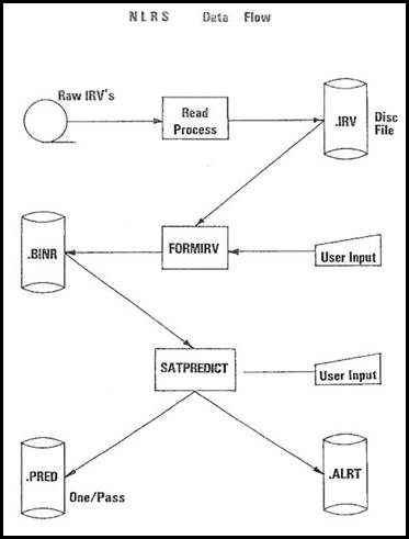
In 1984, Robert John Bryant and John Philip Guilfoyle (who had joined Nat Map as a Trainee Technical Officer in 1971) co-authored a paper An Overview of the NLRS Ranging Software for the Fifth International Workshop on Laser Ranging Instrumentation that was held at the Royal Greenwich Observatory, Herstmonceux Castle, Sussex in the United Kingdom during 10-14 September 1984. (This paper was published on pages 384-395 in Fifth International Workshop on Laser Ranging Instrumentation, Volume II by the Geodetic Institute, University of Bonn, Nussallee, Germany in 1985.) This paper is provided at Appendix B.
The Astro-Geodetic Observatory at Orroral, then operated under the Australian Surveying and Land Information Group, closed on 31 October 1998 and was replaced by a new facility at Mount Stromlo. However, Bob Bryant had left Nat Map over a decade beforehand.
Electro Optic Systems Pty Limited
Bob Bryant joined Electro Optic Systems Pty Limited in 1987. EOS had then commenced operations from premises at 55A Monaro Street Queanbeyan, behind the Black’s Chambers shop fronts. Dr Benny Allan (Ben) Greene had established EOS in 1983.
Ben Green had joined Nat Map as an Engineer in 1977 and went on to head the Astro Geodetic Observatories Branch. Ben gained the degrees of Bachelor of Engineering (Honours) (in electrical engineering) from the University of Queensland (in 1973) and Doctor of Philosophy (in physics) from the University of Hull (in 1980).
Together with Ben Greene and some other Nat Mappers, Bob Bryant joined EOS when Nat Map’s former space-related laser ranging projects were commercialised to the private sector provider. EOS remains an Australian-owned technology and manufacturing company operating in the defence, space and communications fields. Its products use technologies including advanced electro-optic and microwave applications based in software, laser, electronics, optronics, gimbals, telescopes and beam directors technologies as well as precision mechanisms and high-end broadband radio transceivers and satellite communications-on-the-move terminals.
In his early years at Electro Optic Systems, Bob Bryant worked on the development of laser ranging systems including systems that were sold to Japan and to Saudi Arabia. Later, Bob worked on munitions systems. While with EOS, Bob made several overseas trips, including one with Ben Green to England’s Royal Greenwich Observatory at Herstmonceux Castle in Sussex.
Bob Bryant retired from Electro Optic Systems in about 2004. He was then around 61 years of age.
Vale
Sadly, Bob Bryant passed away suddenly and unexpectedly at his home in Cook on 27 July 2022; he was 79 years of age. Bob was survived by Robyn, his wife of some 55 years, and by 4 of their 5 children, namely: Catherine, Elizabeth Jill (Lil), Meredith and Tim. Bob Bryant’s funeral service was held on 5 August 2022 at St James Anglican Church at 40 Beaurepaire Crescent Holt. About 200 people attended Bob’s funeral service; including former Nat Mappers Brian Murphy, Phil Allen, Peter Morgan and Ben Greene.
National Mapping community members who knew and worked with Bob Bryant over the years extend their sincere sympathies for their sad loss to Robyn and her family.
Acknowledgements
During the research and preparation of this article the following people generously provided assistance:
· Robyn Bryant OAM, Bob’s wife of some 55 years
· Dave Abreu, former Nat Map Technical Officer
· Peter O’Donnell, former Nat Map Assistant Director
· Phil Allan, former Nat Map Technical Officer
· Simon Cowling, former Nat Map Senior Surveyor
· Brian Murphy, former Nat Map Senior Surveyor
· Charlie Watson, former Nat Map Senior Surveyor
· Paul Wise OAM, former Nat Map Senior Surveyor and founder, operator, and editor-in-chief of the XNatmap website.
The author gratefully acknowledges the kind assistance provided by each of these people.

Nat Map’s East-West and North-South PAGEOS baselines (red) with ballistic camera sites (blue dots, BC4 023, 032 and 060) and the Johnston Origin to Gulgoora high precision geodetic traverse (green).
Map prepared by Paul Wise.
AN OVERVIEW OF THE NLRS RANGING SOFTWARE
R.J. Bryant; J.P. Guilfoyle
Division Of National Mapping
Department of Resources and Energy
Canberra, Australia
ABSTRACT
The Division of National Mapping in co-operation with NASA have undertaken an upgrade of the National Mapping ranging facility to enable Satellite Laser Ranging as well as a Lunar Ranging to be performed at the site. Because the new system was to be so dramatically different from what existed, this upgrade provided a unique opportunity to design from basics a complete integrated system to fulfil this dual role. This paper provides a brief outline of the ranging system hardware used and an overview of the software system to control it. It should not be taken as a recipe for instant success or necessarily the best way but as an outline of the approach taken by National Mapping to achieve the goal of routine high accuracy ranging.